Tuesday, 3 September 2019

Dover Durness Day 6: Crook to Ford (Etal)


Distance today        93 miles in 7hrs 38mins
Height Climbed      6873 feet burning 2663 Kcal

Distance so Far       498 Miles  in  36hrs 47mins
Height Climbed      21269 Feet Burning 13932 Kcal


I enjoy the traffic free nature of the recycled railway lines, but the surface can be variable. Today I spent the first 18 miles on a railway line which went from gravel down to fines which is smooth but quite slow and needs effort to move along, to a short section with large lumps of stones pretending to be cycleable. So the first 2 hours were run off at just under 11 miles an hour: unhelpful when there are annother 70 or so to go.

Once off the railway line the hills start in earnest. The route created on the Garmin website suggested just over 4000 feet of climbing. On the bike it was just short of 7000. Oh good.

There were big hills and rolling hills. Whatever power I had for hills went days ok. It is just sit in a low gear and peddle. It gets me there in the end. Not pleasant on busy roads though.

The route was better today. I think there was more variation in the landscape. I started in arable, moved into cow country where the land went from brown to green and then up to sheep country.

I didn't notice the wind really. It was there, but I think it was behind me all day.


The problem with rolling hills and straight roads
is as you come to the top of one, you can see the downhill but look ahead and there is the hill to go back up. This results in going as fast as possible down the hill, and then trying to get up the other side as far as possible before having to put some effort in. There was one where I managed to get back up and over the top of the next hill without peddling on the uphill, and it was quite a big lump too. Made me smile.


There was another puncture today. I could feel something wasn't right and some bouncing on the bike revealed a soft front tyre. I kept going as Passepartout was waiting up the road. I came into a small estate village with a corrugated iron village hall in light green with a covered porch with two tables and seats. That will do. I sat, had a gel and set out the wheel. I had messaged ahead but Denise had no signal so came looking for me. It then rained so we had a sandwich looking out at the rain in the shelter of our porch. It stopped and I went on. Only rain today. How lucky was that?


Monday, 2 September 2019

Dover Durness Day 5: East Cowick to Crook


Distance today         105 miles in 7hrs 40mins
Height Climbed       3619 feet burning 2713 Kcal

Distance so Far       405 Miles  in  29hrs 09mins
Height Climbed      14396 Feet Burning 11218 Kcal

Today wasn't a particularly hard day in itself, but on the back of the last four days, it was hard.

I am tired so this will be an illustrated summary.

We finished mid afternoon Sunday in a hotel/wedding venue/restaurant on a quite country road. This turned into a very busy A road with plenty of heavy commercial traffic on Monday morning and I had to go play with it for the first three miles. A few lanes after pulling off the road and the sustrans route was the old taxi way round an air field now used for gliders and a earth track to the main road. 

Selby was easy to go through, and the cycle route nicely avoided the worst of the A14, and then pulled away to the north.  A lovely tarmacked route with in places tree roots pushing up the surface to provide a surprise/traffic calming feature.


This brought me to teh edge of York and its horse race course which the path crossed over at about 7 furlongs from the fiish line. On past the Terry's chocolate factory, now closed, and through by the river. So easy and traffic free to cross the city. Even had traffic lights for cylists.

Passepartout was waiting Beningbourgh Hall, just north of York. I felt my front tyre going down and limped the last 1.5miles to the car to change it and have a sandwich.

It then rained. About 40 mins of steady rain, and then it started to get hard. I don't recall much after that. The roads remained quite. The wind dropped during the rain, but came back after stronger, It was from the west and strong enough to kick the front wheel sideways at any gap in the hedge.

I joined a B road. I was striaght, busy with fast cars and had what felt like large hills in it which I could see coming. Crossing Bishop Auckland in the rush hour was challenging. Not dangerous, but I saw more traffic in 20 mins than I had the rest of the day. I emerged onto another railway track/trail and turned off this about 2.5 miles from the accomdation. 2.5miles of up, 2.5 miles in the lowest gears, just willing it to end.


Sunday, 1 September 2019

Dover Durness Day 4: Burton-le-Coggles to East Cowick


Distance today         87 miles in 6hrs 16mins
Height Climbed       2428 feet burning 2238 Kcal

Distance so Far       300 Miles  in  21hrs 29mins
Height Climbed      10777 Feet Burning 8505 Kcal

Fourth day and wind really got going today. It started where it left off yesterday, a moderate south westerly and turned to moderate to fresh westerly as the day went on. As I was zig-zagging,north then west, taking turns at riding into a block head wind, and then a cross wind.


The day started with pretty much standard: Up a hill, down a hill, across a dual carriageway sheltering in the central reservation, then up a hill. Turn right the Garmin says, but the road said unsuitable for vehicles. It looked rough, but no real potholes. The map suggested the alternative was the dual carriageway. I'll chance the potholes. A couple of miles of weaving at walking pace and back on a normal road. So much for my careful planning on "paved roads".

Further on I picked up a Sustrans route on a canal tow path. This started well with a good surface, then filled with potholes and dog walkers. I put the wheels on the edge of the path, the smoothest part and pushed on. Canal works on a lock put me on a railway. A line of compacted mud in short grass, smoother and faster than the tow path.


More roads. I'm not going well. It is all an effort. I know Passepartout is at 40 miles waiting, but at 30 miles I need a rest. I really like bus shelters, and I find a nice wooden one with a seat. The view is not great, but it is clean and I am out of the wind. It's nice to sit still. I have an eat, drink and watch the cars. I assume a bus won't come. 


I have a sandwich with Passepartout, climb another short hill and have a wee. My body to come back to me and refreshed I move on. It really is a day of two halves.

For the second time today I come across wet roads. I have seen rain to the left and had the odd drop, but not got wet. The road now has water in pools on the sides. It really has rained, but I've been lucky.


Passing by a massive coal fired power station that is clearly off, I ride onto roads which I last rode in 2010 on the Lands End to John O'Groats. The only place I recognize is the pub which I finished the day at last time. Then it was closed and looking sad. Now it is open and very smart. An unusual direction.

5.5miles to go and a road closed sign for somewhere ahead. I push on. A car comes towards me, flashing its headlights. I push on. The road is wet, there is some water in the air. Three cyclists come towards me. I move across the road and ask about the bridge. They stop. You can walk over. Stress for nothing. They are soaked, I thank them and 2 miles after the bridge arrive at my destination.


Saturday, 31 August 2019

Dover Durness Day 3: Great Shelford to Burton le Coggles


Distance today         79 miles in 5hrs 28mins
Height Climbed       2470 feet burning 2204 Kcal

Distance so Far       213 Miles  in  15hrs 13mins
Height Climbed      8349 Feet Burning 6267 Kcal

Great Shelford is on the edge of Cambridge and there was easy access to the massive network of traffic free cycle paths that pass through the city. So within 200 yards of leaving our accommodation, I was riding next to a railway line heading into the city. A short diversion through a science park, and then next to the guided bus network, a curious way of normal buses running in a concrete track with little guide wheels keeping them inside the walls of the concrete channel. They have car traps to stop cars using them. 

Then onto a series of back streets, parks and on road cycle paths, over the river and back to the guided bus network. A major city crossed with little fuss. There were even diversions for the cycle track, which was great until it stopped and left me abandoned. I tried to get back onto the route though another science park (a posh name for a trading estate in Cambridge). I found a way though, but the gate was locked. Only open day time on weekdays. Bugger. I tracked back along the back on the units and found another way back onto the track.


The tailwind had returned, and on this good tarmac surface I pushed on. I could see another closure under a bridge. High metal barriers obscured the view through, buses were diverted. But as I closed there was a cycle/foot path through.It didn't last though. Another closure. This time someone in a van.

 
How do I get round, I'm not local? The young woman, probably an intern, had been told that
everyone would know but clearly not. She suggested left then right. I checked the map. It should
work. I'd been warned that there may be a closure, but it is really frustrating to have a closure and no proper diversion. We agreed that a piece of paper and a map would've helped. I moved on. Following my nose, and at the cost of three miles, I returned to the route.

Not to say its not flat round here, but 30 miles done and only 600 feet of climbing done. Passepartout and I met in Great Stukeley, and we shared current buns and filled a water bottle and off again.

The day passed: Rolling hills, quite roads, a flower Concorde, an
old American plane at some unused base, then the tar and chipping started. 3 sections of a couple of miles. At least they weren't done yesterday, with the sea of chippings they leave for the cars to roll in, and the cycles to slide on. No there was enough here to slide on corners and for the odd car to pass at 50 and fire stones at my legs. 


Another meeting with Passepartout and onto Rutland and a cycle event sign.
Maybe a time trial or a sportive. At the next junction there were Raynet members, amateur radio enthusiasts who assist at events. It was the ladies race of the Bourne Classic Cycle Race, confirmed by a later sign. They were 50 minutes behind me. At the speed I was traveling they could catch me soon!

Onwards and clouds came in. The wind picked up futher. My tail wind was cross tail so still useful. Less than 10 miles to go, would I get wet? I pushed on. I want to keep the bike in the room tonight so it must stay dry. 1.5miles to go, it starts to spit, I can see the rain to my left. I push on and pull into the pub carpark and the bike and I head for cover. The rain stops.


Friday, 30 August 2019

Dover Durness Day 2: Horndon on the Hill to Great Shelford


Distance today         63 miles in 4hrs 05mins
Height Climbed       2293 feet burning 1613Kcal

Distance so Far       134 Miles  in  9hrs 45mins
Height Climbed      5879 Feet Burning 4063 Kcal


There is nothing quite like a nice straight downhill to get into the swing of things, so it was a lovely surprise and a great start to the day to find a 1:10 downhill just half a mile from the nights accommodation. It was quite early too, well earlier than intended. We were up and fed and ready to go by 8.30 so no point in hanging around, especially as it was sunny.

Essex is nice, but fairly flat and quite samey. Arable and quite a lot of trees, and a bit rolling. Most of the crops are in, so it is mostly ploughed fields.


There was a field of sun flowers looking over the hedge at me which was a surprise.


Dominating today was road works. Generally a "road closed" sign means might be closed to a cyclist. The one yesterday, was passable on the footpath, then down the road dodging the large holes dug for updating the mains.

Today though it was closed. Proper closed. The trench across the road was about 4 feet wide and the man I talked to was up to his chest in it. I thought about taking a run up at it, but maybe not. He told me to take the diversion, but these are often a long way, further than necessary, as they can only divert onto roads of the same class or higher. He said that yes, I would end up on a very busy A road and suggested a different side road. A big hill and a ride on the distgribor roads though Basildon and I was back on course.

Later in the day there was another: This time the whole bridge was missing. The gap was wide and deep and over a electirfied railway line. A look on the map suggested I could get down a lane and across the railway on footpath. It worked. Only getting of the bike to wheel it across the track after obeying the traffic lights for the pedestrian.

The bee has been having a great time. He is enjoying the village signs found in teh center of the villages and having a close look at a few. 


We passed the end of the runway at Stansted. I didn't notice a thing.
Passepartout, drive the other way and said she had planes taking off over the car, at my end nothing. Except these signs, which we decided to strictly disobey
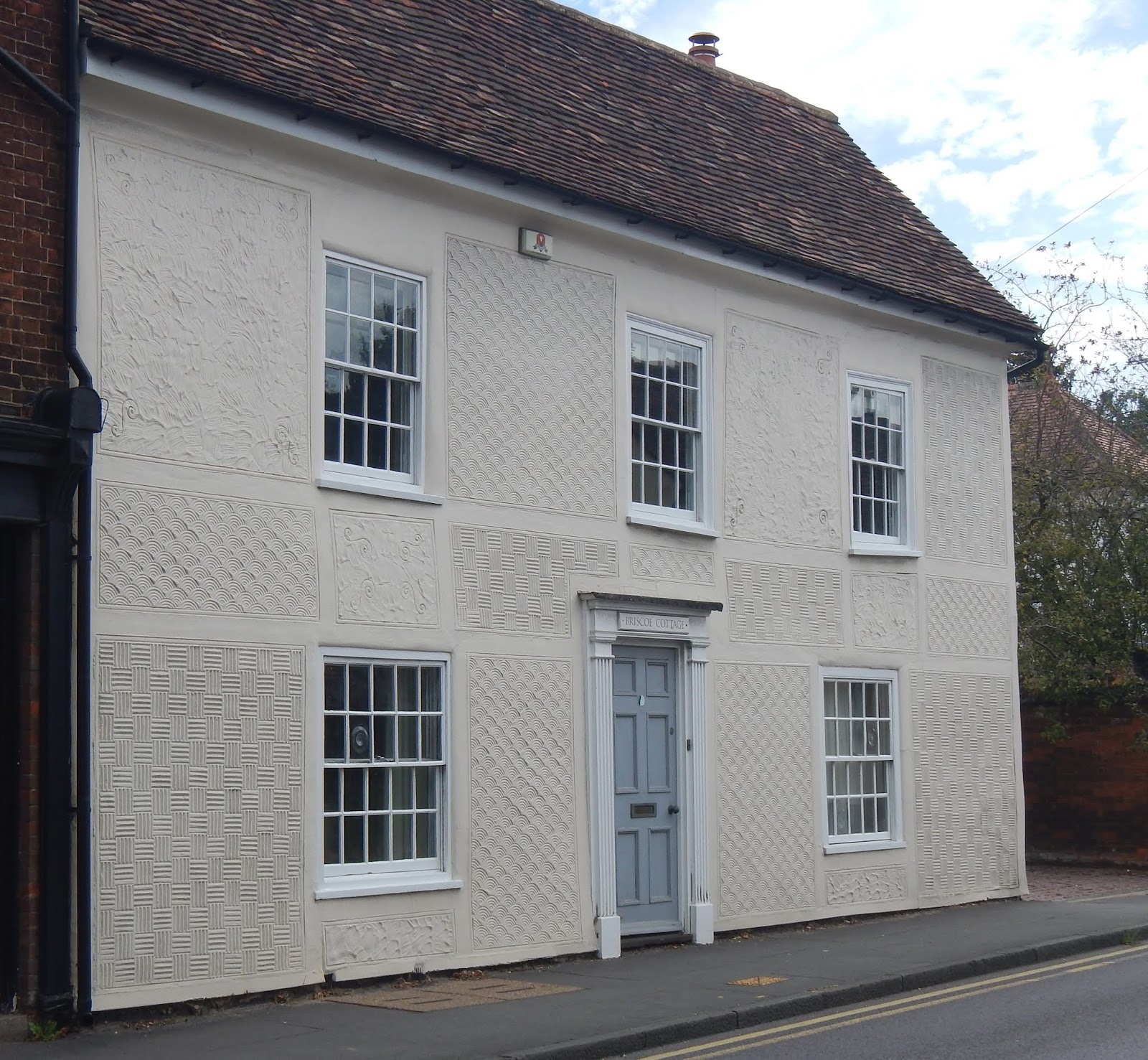
 We also found some nice buildings including some pargeting


 After the rather short day today with its lovely tailwind we are back up to 75 miles. This is all very well but as I am doing 850 miles in 10 days and am well below the average at present you can be sure some longer harder days are on their way. Lets hope for more tail wind, or at least cross tail.